Urban Floodplains in India: The Hidden Cost of Riverfront Development
-
by
 TBH Editorial
 - No Comments on Urban Floodplains in India: The Hidden Cost of Riverfront Development
A polished promenade beside a river can look like progress. Yet when that makeover lands on a floodplain, the city often trades living protection for hard-edged display.
Across urban floodplains in India, riverfront projects often squeeze, wall off, or rebuild the land that absorbs overflow, cools neighborhoods, filters runoff, and shelters birds, fish, insects, and river-based livelihoods. The river may look cleaner in a brochure, but it often becomes less stable in the monsoon.
That gap between appearance and function is where the real story begins.
A floodplain is part of the river, not spare land
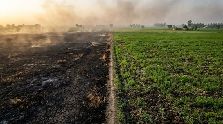
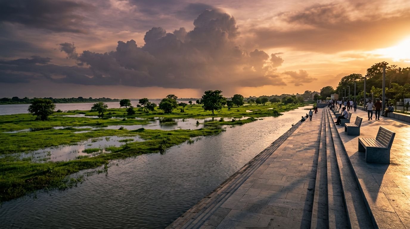
A floodplain is the river’s breathing room. During heavy rain, water spreads into this low-lying land, slows down, drops silt, and seeps into the soil. In dry months, that same ground may look flat, open, and ready for construction. But the dry season doesn’t cancel the river’s claim.
That misunderstanding sits at the center of many riverfront plans. Planners often treat floodplains like vacant urban land, a place for walkways, parking, event grounds, landscaping, roads, and real estate. In a monsoon country, that is a risky reading of space. The river expands by design. When a city blocks that expansion, floodwater doesn’t disappear. It shifts into roads, homes, drains, and low-income settlements.
A floodplain is the river’s safety valve. Build on it, and the water looks for space somewhere else.
This matters even more in Indian cities because rivers already face sewage discharge, encroachment, sand mining, and shrinking wetlands. Urban floodplains in India are doing several jobs at once, even when they look neglected. They store water, recharge groundwater, support native grasses and riparian plants, and give room to species that can’t survive on a concrete edge. They also buffer heat. A river corridor with moist soil and vegetation cools the city in a way stone embankments and tiled plazas cannot.
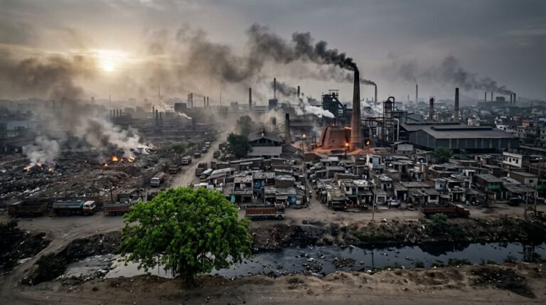
When floodplains are damaged, the loss is easy to miss at first. There may still be a river. There may still be trees. There may still be a public walkway. But function has been replaced by form. A row of ornamental palms is not a floodplain. Neither is a paved promenade with decorative lighting. A riverfront that ignores the floodplain can look organized while making the city less safe.
Why “empty” river land keeps attracting urban development
Riverfront projects win political support because they are highly visible. A restored wetland is harder to package than a lit-up promenade, a plaza, or a headline image of “world-class” urban renewal. Floodplains also sit in prime locations, close to roads, institutions, business districts, and rising land values. That makes them tempting targets for city branding.
Research has tracked this pattern in Delhi. Research in ScienceDirect on Delhi’s riverfront mega-projects examined how floodplain development and the clearing of settlements moved together under the language of modern urban transformation. That pairing matters. Riverfront beautification can hide a harsher process in which ecological space is redefined as buildable land and vulnerable people are pushed aside first.
A related SPRF analysis of the Yamuna riverfront points to the hydrological cost of that urbanization, including stronger runoff and higher drainage pressure. In plain terms, when rain hits hard surfaces near a river, more water moves faster into the system. That raises stress on drains, embankments, and nearby neighborhoods.
The visual logic is powerful because floodplains often look messy. Native reeds, seasonal pools, alluvial soil, and shifting channels don’t fit the neat lines of urban design presentations. Yet that “mess” is how rivers work. Once the floodplain is flattened into a permanent civic set piece, the city loses flexibility. It becomes dependent on walls, pumps, dredging, and emergency response. What looked like order starts to behave like a maintenance trap.
There is also a planning bias at work. Many city agencies still think in terms of fixed edges and engineered control. Rivers don’t follow that script. They move, deposit, erode, spread, and retreat. Development that ignores that movement often turns a public works project into a long-term flood problem.
What construction changes first on a river’s edge
The first damage often looks technical and harmless. Soil is graded. Banks are straightened. Side channels are cut off. Retaining walls go in. Earthmovers flatten uneven ground. Native vegetation disappears because it doesn’t match the design. A river edge that once slowed water and held life becomes a hard boundary.
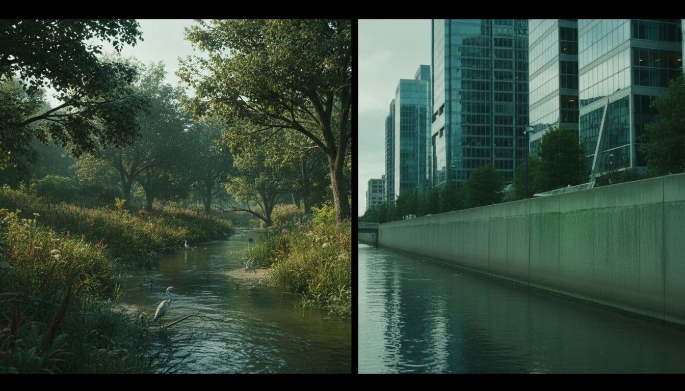
This shift changes more than appearance. Natural banks absorb impact, hold roots, and create micro-habitats for insects, amphibians, nesting birds, and small fish. Concrete edges reflect heat, speed runoff, and break those habitats apart. Even when projects add lawns and ornamental plantings, they rarely replace the layered ecology of a living riverbank. Urban biodiversity falls because many species need shallow edges, mudflats, reeds, and seasonal wet patches, not trimmed grass.
Construction also alters how water moves through the city. Hard surfaces block infiltration, so less water seeps into the ground. That weakens groundwater recharge at a time when many Indian cities already overdraw aquifers. Meanwhile, stormwater reaches the river faster. The river rises harder during intense rain, especially when drains are choked or backflow begins.
Another loss is sediment logic. Floodplains are where rivers spread silt, rebuild soil, and shift their form over time. Once a city fixes the edge with walls and embankments, that natural process is interrupted. Then more money goes into dredging, desilting, bank repair, and surface maintenance. The project may still be sold as improvement, but the river has been forced into a narrower role.
At that stage, the riverfront stops being a living system and starts acting like a corridor for managed appearances. The damage may not show on opening day. It shows during the next heavy rain, the next fish decline, or the next summer when the corridor feels hotter than the older riverbank it replaced.
The hidden bill: floods, heat, birds, and livelihoods
Once the floodplain is reduced, the city begins paying a hidden bill. The first part is flood risk. A recent Mongabay report on riverfront conflicts described ecologists warning that active riverfront plans can damage biodiversity and raise flood danger when they disturb floodplains and natural banks. That warning matches a basic hydrology lesson. If you reduce the space available to floodwater, pressure builds elsewhere.
The second part is the wider ecological impact. RMSI’s explainer on why floodplains should stay untouched lays out the core functions floodplains provide, from flood protection to erosion control and water quality support. Those services are easy to forget because they don’t arrive as a ribbon-cutting photo. They arrive as disasters that don’t happen as often when the river has room.
A quick comparison makes the trade-off plain.
| Floodplain function | Natural river edge | Engineered riverfront edge |
|---|---|---|
| Flood storage | Spreads and slows overflow | Pushes water downstream or into built areas |
| Groundwater recharge | Lets water soak into soil | Blocks infiltration with concrete and paving |
| Habitat | Supports reeds, insects, fish, birds | Replaces native habitat with walls, lawns, and lights |
| Water cleaning | Traps silt and filters runoff | Speeds polluted runoff into the channel |
| Public use | Allows low-impact seasonal access | Favors fixed infrastructure and high-maintenance surfaces |
The takeaway is simple. A floodplain is public infrastructure even when it has no ticket gate, no plaza, and no branding.
The damage also lands unevenly. Fishers and other river-based workers can lose income when habitat changes reduce fish numbers or restrict access points. Nearby residents lose groundwater recharge and heat relief. Children lose a chance to encounter a real river ecosystem, which weakens climate literacy at the exact moment cities need more of it. When a river becomes a viewing strip instead of a living corridor, the public gets less nature, not more.
Why beautification politics keeps beating ecology
The answer isn’t hard to find. Beautification is legible. Wetland protection is not. A paved edge photographs well. Native scrub, seasonal pools, and open flood storage look unfinished to officials under pressure to “show results.” That political habit turns rivers into stage sets.

Photo by Jimmy Liao
Budget systems reinforce the same bias. It is easier to cost a retaining wall, pathway, lighting package, and event zone than a living floodplain whose value appears in avoided flooding, cooler air, cleaner water, and healthier bird populations. Procurement also tends to favor civil works over restoration. Contractors know how to pour, tile, and wall. Fewer city tenders ask for native riparian restoration, floodplain mapping, wetland repair, or community monitoring.
There is also a social story hiding beneath the design language. Riverfront schemes often clean up the image of a city by controlling who gets to occupy the river edge. Low-income users, informal workers, grazers, fishers, and floodplain farmers rarely appear in glossy concept art. Yet they are part of the river’s real economy. When cities erase their access in the name of order, public space becomes narrower even when the promenade is wider.
For climate-conscious readers, this is a useful check on personal ethics. Plant-based living can lower your footprint. Everyday mindfulness can sharpen your attention to place. Both matter. Still, neither can offset a planning system that hardens floodplains for visual gain. The problem is structural. It sits in zoning, tender design, environmental review, land politics, and the weak status of urban ecology inside city hall.
What a better riverfront could look like in India
A better approach starts with one rule: protect the active floodplain first, then design around it. That means mapping seasonal spread, keeping core inundation zones free of permanent construction, restoring wetlands, and using native riverbank vegetation instead of ornamental planting. Public access can still exist, but it should be light-touch and seasonal where needed. Boardwalks, shaded trails, bird hides, and permeable paths belong outside the most sensitive zones.
Systemic change also means changing what cities reward. If a project scorecard only counts paving, lighting, tourism, and land value, floodplains will keep losing. If it counts groundwater recharge, bird habitat, wetland area, flood storage, sewage interception, and community access, different designs will follow. Floodplain science should be part of climate literacy for planners, schools, resident groups, and local media. People protect what they understand.
The same logic applies to the economy around rivers. A real circular economy would keep water, soil, biomass, and materials in healthy loops instead of treating them as waste to be hidden under concrete. Cities can support sustainable business models based on wastewater treatment, native plant nurseries, wetland restoration, river monitoring, silt reuse where safe, and low-impact public amenities. Those are jobs too. They simply produce living systems instead of hard surfaces.
This is also where community action matters. If you want to support field-based work that strengthens urban biodiversity and public climate literacy without flattening living ecosystems, Explore Our Active Missions. Tangible local work builds a better civic instinct, one that values repair over spectacle.
Personal choices still have a role. Plant-based living can reduce pressure on land and emissions. Everyday mindfulness can help people notice how rivers smell after sewage discharge or how floodwater spreads after a storm. Yet awareness has to push toward public accountability. Urban floodplains in India won’t be protected by private virtue alone. They need law, monitoring, better design standards, and residents willing to challenge projects that confuse beautification with repair.
Conclusion
A shiny riverfront can hide a broken bargain. When cities build over floodplains, they lose the very ground that stores water, cools heat, supports life, and absorbs monsoon stress.
The strongest lesson is plain: urban floodplains in India are not empty margins waiting for design. They are working ecological systems. If a project leaves less room for water, soil, birds, and people who depend on the river, it is not renewal. It is a transfer of risk.
The most honest riverfront is the one that respects the river’s shape, season, and space.