
Why India’s Wetland Maps Miss Seasonal Lakes
 TBH Editorial
A lake can disappear from a map without disappearing from the lives around it.
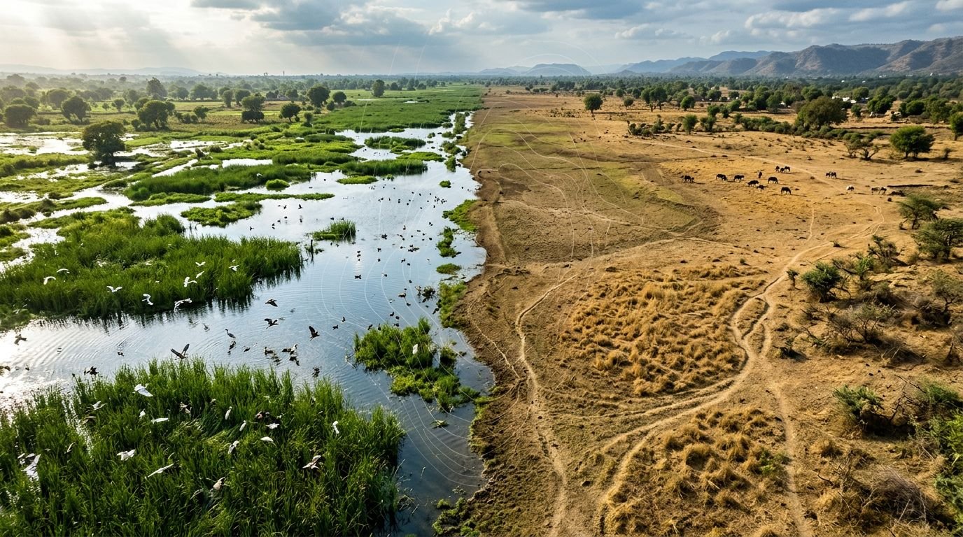
For months, a seasonal wetland may look like dry grass, a grazing patch, or an empty plot waiting for construction. Then the monsoon arrives. Water spreads, birds return, wells recharge, and the same vacant land prevents a neighbourhood from flooding.
That is the significant blind spot in how many India seasonal wetlands are seen, counted, and protected. This persistent failure to account for these temporary aquatic ecosystems represents a fundamental hurdle for effective wetland conservation.
Key Takeaways
- India’s wetland maps have improved, but many seasonal lakes remain hard to identify because they change sharply between monsoon and summer.
- A satellite image taken during one dry month can confuse a living wetland with farmland, scrub, or unused land.
- Small wetlands are essential for flood mitigation, groundwater recharge, birds, fish, livestock, and local urban biodiversity.
- Mapping must combine seasonal satellite data, field verification, public access, and legal protection.
- Systemic change means treating seasonal water bodies as critical infrastructure for climate adaptation strategies, rather than as empty land between construction projects.
A Wetland Is Not Empty Because It Is Dry Today
India’s wetlands are not all wide, permanent lakes. Many are small, shallow, scattered, and seasonal. They fill during rain, hold water for part of the year, and slowly release it into the soil, streams, wells, and nearby fields. These sites serve as nature’s kidneys by filtering pollutants, and they are essential for maintaining healthy hydrological cycles and supporting groundwater recharge.
That cycle makes them easy to ignore.
A planning officer visiting in May may see cracked earth. A satellite image from the same period may record dry vegetation. A developer may see an opportunity. But the people who live nearby often know better. They remember where water gathers in July. They know which patch draws herons after rain. They know where the road floods when an old pond is filled.
The problem is that official records often reward what stays visible all year. Permanent water is easier to draw as a blue shape on a map. Seasonal wetlands keep changing shape, color, depth, vegetation, and land use.
India’s 2024 National Wetland Atlas, prepared through the National Wetlands Inventory and Assessment programme, lowered its mapping threshold to 0.1 hectare. That is a meaningful improvement over older inventories that missed smaller sites. It identified more than 231,000 wetlands, covering about 4.86% of India’s geographical area. Even with these advancements, aligning local geography with the broad criteria of the Ramsar Convention remains a challenge, as the international framework struggles to capture the full scope of seasonal variability.
Still, smaller and scattered sites remain outside the record or lack enough information for protection decisions.
A 2026 study on tracking wetland methane across India puts the problem plainly: Indian wetlands are often fragmented and heavily shaped by the South Asian monsoon. One image cannot tell their full story.
A seasonal lake is not failed farmland. It is water infrastructure working on a seasonal clock.
When a wetland disappears from the map, it becomes easier to erase it from the ground.
Why Satellite Images Miss Seasonal Wetlands
Satellite mapping is an essential tool, and India relies heavily on it. The Space Applications Centre, ISRO, and various state remote-sensing centres have established a far stronger base of wetland information than existed just a few decades ago. However, satellite data is merely a photograph of a specific moment in time, rather than a complete biography of a landscape.
Seasonal wetlands often present a shifting reality. For instance, the Chhari-Dhand wetland in Gujarat undergoes dramatic transformations between seasons, and many Ramsar sites across India face similar mapping challenges due to these inherent fluctuations. National wetland assessments have recorded a massive drop in open-water extent between post-monsoon and pre-monsoon periods, where open water can shrink from roughly 224,655 hectares to 148,382 hectares.
This is not just a minor technical mismatch; it is the difference between a recognised wetland and an unprotected plot of land. Several issues make accurate mapping particularly difficult:
- Timing changes the answer. Imagery collected before the monsoon often misses water that spreads later across a shallow basin. This is critical for the Central Asian Flyway, as missing a seasonal window means failing to account for the essential habitat used by migratory birds.
- Vegetation hides wet ground. Reeds, grass, crops, and floating plants frequently cover water or saturated soil, rendering them invisible from above.
- Small sites get blurred. A pond edge, a drainage channel, and a surrounding field can all sit inside the same satellite pixel.
- Wetland boundaries move. Water expands, contracts, and seeps through soil, meaning the edge is rarely a neat line.
- Human use confuses classifications. Seasonal wetlands may be grazed, farmed, fished, or used as informal dumping grounds, which obscures their natural ecological function.
Optical imagery also struggles under heavy cloud cover, which arrives precisely when monsoon water is most visible. While radar data, such as Sentinel-1 synthetic aperture radar, can help by reading surface conditions through clouds, these technologies are not used consistently across every state and district.
The core issue is not purely technological. The failure lies in treating a single seasonal snapshot as the final truth. According to the Ramsar Convention guidelines for inventorying, a proper wetland record should compare pre-monsoon, monsoon, post-monsoon, and dry-season conditions. It should also include extensive field checks by local experts who understand the site. A map should fundamentally ask: Does this area hold water? For how long? Where does it drain? Who depends on it? What species use it?
Without answering those questions, a seasonal lake can be mislabelled as wasteland and pushed toward real-estate development paperwork, ultimately leading to the destruction of vital ecosystems.
The Cost of Missing a Seasonal Lake
The ecological impact does not stop at one patch of water.
A seasonal wetland slows runoff. It stores water when drains are overloaded. It can recharge groundwater, trap sediment, support amphibians, and give migratory birds a place to rest. It also offers small but meaningful cooling in overheated towns.
When these spaces are filled, paved, or cut off from their catchments, the damage often appears elsewhere. Water enters homes faster. Borewells go deeper. Streets flood after short bursts of rain. Migratory waterbirds vanish. The city then spends public money on pumps, drains, tankers, and flood repairs.
That is a bad bargain.
The loss is especially sharp in expanding cities. Peripheral wetlands are often swallowed by roads, warehouses, apartment blocks, landfill edges, and speculative plots. Their seasonal nature makes them politically weak. While a permanent lake has a visible constituency, smaller sites like the Patna Bird Sanctuary show that even protected or recognized areas struggle when their seasonal nature is ignored. A low-lying monsoon pond is often defended only after water enters somebody’s living room.
Research on the status and loss of wetlands in India links wetland decline to urbanisation, land-use change, and pollution. Those pressures have not disappeared. They have become more organized, better financed, and harder for nearby communities to challenge. Poor urban planning often fails to account for these vital patches, treating them as empty land rather than essential infrastructure.
Urban biodiversity pays the price first. Frogs, fish, insects, waterbirds, and wetland plants do not get a public hearing before a site is filled. Yet their absence changes the local food web. A city with fewer wetlands also has fewer buffers against climate extremes, leading to increased heat, flooding, and contaminated runoff.
We should be honest about the language here. Calling a seasonal wetland vacant does not make it vacant. It makes its unpaid work invisible.
This is also where everyday mindfulness matters. Look at the low ground near your home after rain. Does water pool there every monsoon? Are egrets, dragonflies, or frogs suddenly present? Has a former pond become a parking lot? Local observation is not a replacement for science, but it is often the first warning that the official record is wrong.
Mapping Is a Governance Problem, Not Only a Data Problem
India does not need another glossy atlas that sits on a server while wetlands disappear beside it. Effective environmental governance is missing when mapping data fails to translate into on the ground enforcement. A map only protects a place when it changes a decision. Does it stop a construction approval? Does it alter a drainage plan? Does it force a developer to maintain water flow? Does it give residents a clear path to challenge illegal filling?
Right now, the chain often breaks between mapping, public access, and enforcement.
Some wetland information remains difficult for ordinary residents to find, interpret, or contest. State boundaries, departmental silos, old land records, and unclear classifications create room for convenient confusion. A wetland may appear in one database but not in a local master plan. Its catchment may have no protection at all.
The result is predictable. Water bodies are treated as isolated blue shapes, while the drains, fields, slopes, and channels that feed them are handed over piecemeal.
Real accountability would include:
- Seasonal maps updated across multiple years, not a one-time inventory.
- Public, searchable wetland data with boundaries, seasonal extent, ownership, and threat status.
- Ground verification with local communities, fishers, farmers, bird groups, and ward-level officials.
- Planning rules that protect wetland catchments and natural drainage to ensure long term water security, rather than only protecting visible open water.
- Commitment to the Ramsar Convention principle of wise use, ensuring that any wetland management supports ecological integrity while serving human needs.
- Penalties for illegal filling that are strong enough to matter before the damage is permanent.
This is where sustainable business models need a harder standard. A project cannot call itself responsible while building over seasonal flood storage and then selling expensive drainage solutions to the same city. Nor can a so-called circular economy excuse dumping construction debris into a wetland because the material has been reused. If a project claims to promote the sustainable use of resources, it must respect the natural infrastructure already in place.
Waste moved into a water body is not circular. It is pollution with a better label.
Climate literacy should include this basic lesson: water does not vanish because a map ignores it. It moves. It floods roads, enters basements, carries sewage into homes, or leaves neighbourhoods thirstier by summer.
What Communities Can Do Before a Wetland Is Lost
Residents should not have to become unpaid hydrologists to protect common water, but local stewardship is often the only defense when official records are weak. When official maps fail to capture the reality of the landscape, community-led data becomes an essential tool for effective conservation planning.
Photograph the same site across seasons. Record flooding, migratory waterbirds like those found in the Chhari-Dhand or the Patna Bird Sanctuary, native plants, drainage routes, dumping, and construction activity. Keep careful dates. Compare old satellite images with present ground conditions. Use events like World Wetlands Day as a focal point to showcase this seasonal data, presenting your findings to ward offices, municipal hearings, pollution-control bodies, and local media.
Ask simple questions that are hard to dodge:
- Was this site assessed during both the monsoon and the dry months?
- Is it listed in the wetland atlas, revenue records, or city development plan?
- Where will rainwater flow after this land is built over?
- Has the project blocked a feeder channel or filled low-lying ground?
- Can the public see the environmental clearance and drainage plan?
Community action becomes stronger when it connects human safety with ecological care. Parents worried about flooded school routes, street vendors losing workdays, and residents facing water shortages all have a stake in protecting these vital ecosystems.
Personal choices matter too. Plant-based living can reduce wider pressure on land and water systems. Lower-waste habits can keep plastic and toxic runoff out of drains. However, individual restraint cannot replace robust planning laws that treat seasonal wetlands as permanent features rather than disposable land.
That is why local action needs public systems behind it. Explore Our Active Missions to support work that connects climate literacy, community dignity, and living ecosystems rather than separating them into neat categories.
Frequently Asked Questions
Why are seasonal wetlands often excluded from official maps?
Seasonal wetlands are frequently omitted because official inventories often prioritize permanent water bodies that remain visible year-round. Because these wetlands change drastically between the monsoon and the dry season, a single satellite image taken during the summer can easily misidentify them as dry land or unused property.
What are the consequences of building over a seasonal wetland?
Filling these areas for construction removes essential natural flood defenses and disrupts local groundwater recharge cycles. This often results in increased neighborhood flooding, higher public spending on emergency drainage and water pumps, and a loss of critical habitats for migratory birds and local biodiversity.
Can local residents help protect wetlands that are not officially recognized?
Yes, community documentation is a powerful tool for conservation when official records fall short. Residents can track the seasonal changes of a site through regular photography, document local wildlife sightings, and present this data during municipal planning hearings to challenge the classification of the land as empty or disposable.
How does the Ramsar Convention relate to India’s seasonal lakes?
The Ramsar Convention provides a global framework for identifying and protecting wetlands of international importance, yet it often struggles to account for the ephemeral, seasonal nature of many Indian water bodies. By documenting and properly recognizing these temporary sites, India can improve its local conservation efforts and potentially designate more diverse, seasonal ecosystems as protected Ramsar sites.
Conclusion
India’s seasonal wetlands are not missing because they lack value. They are missed because maps, planning systems, and land markets often value only what stays visible all year. To ensure future ecological resilience, we must shift our perspective to treat these temporary water bodies as vital infrastructure.
Integrating seasonal wetlands into official protection frameworks is a crucial step toward India adding more diverse Ramsar sites to its international conservation list. While Ramsar sites are widely considered the gold standard for global wetland protection, they often overlook the ephemeral nature of India’s seasonal lakes. By properly documenting and recognizing these areas, the country can expand its network of protected areas and ensure that more habitats meet the criteria for Ramsar sites.
Better mapping must follow water through every season, then give communities the power to defend what those maps reveal. Systemic change starts when a dry patch in summer is recognized as a lake in waiting, a habitat in motion, and protection against the next hard rain.